Nine landslide events in five days. This is what extreme weather can do to fragile land.
On 27 March 2026, a landslide of clay and debris closed the Provinciale 90 near Fossacesia in the province of Chieti, the slope giving way onto the carriageway.
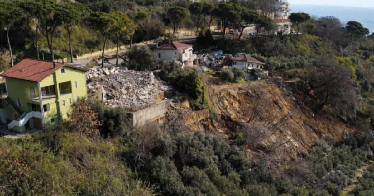
On 29 March, a landslide cut a 250-metre scar through Silvi Paese in Teramo province. Three houses collapsed, and thirty-two families lost their homes. The damage is estimated at about four million euros. Warning signs had been visible for weeks, like cracked roads, bowed retaining walls, and small dips in the farmland above.
On 31 March, a further landslide closed the Provinciale 56 at Colonnella, with a 30-metre-wide ground movement that dropped the road surface by up to 20 centimetres and raised fears for nearby homes. On the same day, a landslide also closed the road between Fallo and Montelapiano in the Chieti interior.
On 1 April, two slope failures hit Chieti city within hours of each other. A slope collapsed on Via Masci, one of the main access roads into the city centre, spilling onto the carriageway and bringing traffic to a standstill. A second collapse at Madonna del Freddo on the road up to Villamagna. A section of the Statale 150 between Val Vomano and Castelnuovo in the province of Teramo collapsed at around 9 am, and a landslide occurred at the boundary of Rapino, another in Sant’Egidio, both in the province of Chieti.
This is the predictable result of rainfall driven by climate change on clay-rich hillsides where risks are known, maps exist, and surveys have been done. The problem is that the national budget for landslide and flood prevention has been slashed by over six billion euros for the coming decade, leaving communes without the funds to act on what they already know. And the weather is getting worse, not better.
The ground in Abruzzo is not dangerous everywhere. Certain places are known to be fragile, and this can be measured and documented. This article aims to help you determine whether the place you are considering is one of them.
HOW WIDESPREAD IS THE RISK?
The short answer is: almost everywhere.
According to the latest ISPRA report covering 2022 to 2024, the surface area of land mapped as at landslide risk across Italy grew by 15% in that period. In 2024, 94.5% of Italian comuni were classified as at risk from landslide, flooding, coastal erosion or avalanche. Abruzzo ranks among the regions with the highest proportion of territory in the elevated danger categories and among those with the highest number of residents at risk relative to the total population.
In Abruzzo, 304 out of 305 communes have small areas classified as having elevated or very high landslide danger. Only one commune in the whole region is clear.
At the provincial level, Chieti has the worst picture: 22.5% of its territory falls into the highest-risk categories, and 7.4% of its population lives in those areas. Pescara follows at 16.6%, then Teramo at 15.8%, and L’Aquila at 11.4%.
WHY ABRUZZO’S HILLS MOVE
Several factors make Abruzzo’s terrain unstable. Knowing about them helps you understand what to look for.
The Rock Beneath it
Much of the hill country, especially in the provinces of Chieti and Pescara, is built on clay and mixed sedimentary soils. Clay soils are prone to movement when they get saturated with water. They expand when wet and shrink when dry, and each wet-dry cycle makes them weaker. This has been known for decades, which is why these areas have appeared on landslide maps for so long.
Position
Abruzzo’s villages were built for defence on ridges and spurs above the valleys, which are the most exposed spots on a hillside. A house on flat ground does not face the same risks as one on a clay ridge 400 metres above a river. In these places, the beauty and the risk go hand in hand.
The Legacy of Abandonment
In the Apennine interior, many people have left the land over the years, leaving terraces, drainage channels, and retaining walls to decay. Saturated ground, blocked drains, and leaks in old water and sewer pipes slowly weaken a slope from the inside. When the weight of the soil exceeds what the ground can support, the hill starts to move. At first, it is barely noticeable, but then it speeds up.
Seismic Activity
Abruzzo is one of the most earthquake-prone regions in Italy. Earthquakes can weaken slopes and building foundations in ways that are not always visible. A hillside that stayed intact before a tremor may have hidden damage afterwards. Reconstruction after earthquakes in parts of Teramo and L’Aquila is happening on land that was already under stress before the shaking began.
WHAT CLIMATE CHANGE IS DOING
The risk is increasing, not decreasing.
Projections for central Italy and the Apennines show that the annual number of landslide events is expected to rise by 30% by mid-century and by 45% by the end of the century. This is not because of more rain overall. It is because the rain that does fall arrives harder and faster, more water in less time, onto ground that is already wet.
The risk is highest during the cold, wet season, from October to March, when the soil is already saturated and heavy rain falls on top of it. The nine landslides in five days in late March and early April 2026 fit this pattern exactly.
There is an additional, specific threat across the Apennines. The networks of check dams and retaining systems built across Apennine hillsides between the 1930s and 1960s were designed for the rainfall patterns of that era. More intense downpours can overwhelm and collapse these in sequence, moving more material than any historical event on record. Much of this infrastructure has not been maintained.
Abruzzo is specifically named as one of Italy’s most exposed regions to the increasing landslide risk posed by climate change. The trend is only going one way.
AREAS THAT CARRY HIGHER RISK
If a town appears on this list, it does not mean the whole town is dangerous. Usually, the risk is limited to a specific slope, district, or one side of a hillside. The rest of the area may be completely stable. This list means you should do extra research before making any decisions.
Recently Updated on the PAI (2025 to 2026)
These communes had new or expanded small danger zones formally added to the official risk map within the last 18 months. An older survey of these addresses may no longer be accurate.
- Notaresco (TE) – new P3 zones added October 2025, including active scarp classifications.
- Montelapiano (CH) and Villa Santa Maria (CH) – two new P3 areas added in February 2026.
- Spoltore (PE) – new P3 zone added February 2026, on the edge of the Pescara urban area.
- Lettomanoppello (PE) – PAI expanded October 2025 to include the town centre and areas to the south-east, all at P3, very high danger.
Active remediation funding awarded from 2025 to 2026
Spending money on a problem confirms the problem exists. These communes have received government funding specifically for landslide stabilisation.
Bucchianico (CH), Gessopalena (CH), Cagnano Amiterno (AQ), Roseto degli Abruzzi (TE), Rosciano (PE), Lettomanoppello (PE) and Corropoli (TE) all received funding under the 2025 national plan for areas classified at very high risk.
Campli (TE), fraction of Paterno – 800,000 euros approved in March 2026 for slope stabilisation. The landslide had been blocking post-earthquake reconstruction work.
Crognaleto (TE) and Colledara (TE) – emergency funding in the same March 2026 package for active slope instability.
Places with areas that have a long-documented landslide history.
These are not new discoveries. They have appeared in historical records, academic studies, and regional surveys for decades. The risk has been known for a long time, but that does not mean it has been solved.
Lettomanoppello (PE)
One of the most serious and longest-running landslide situations in the region. A conference in December 2024 discussed a proposal to build a tunnel 70 metres below ground to stabilise the slope and manage underground water. This is a major engineering challenge still being worked on.
Campli (TE)
Historical studies showed that the medieval town could not expand in any direction due to active slope instability on all sides. Paterno, one of its hamlets, is currently receiving structural intervention.
Penne (PE)
A well-known case in regional landslide literature, with documented slope movement affecting parts of the historic hill town.
Guardiagrele (CH)
Active remediation work at Colle Barone has been ongoing, with nearly 3.5 million euros committed. The town sits on clay-rich terrain typical of the Chieti hill country.
Rapino (CH)
Confirmed landslide at the village boundary on 1 April 2026, during the same extreme weather event that caused multiple failures across the province.
Taranta Peligna (CH) and Lama dei Peligni (CH)
Both appear in long-term ISPRA landslide records and historical surveys as places with documented slow-moving ground.
Castelli (TE)
The ceramics village in the Gran Sasso foothills has had repeated PAI updates, including adjustments in 2025 linked to post-earthquake reconstruction.
Collelongo (AQ), Gioia dei Marsi (AQ) and Balsorano (AQ)
The three communes in Abruzzo have the highest percentage of residents living in high-risk zones. In each case, more than half the population lives within a classified danger area. Collelongo has the highest figure of any comune in the region at 97%.
The coastal spurs between Teramo and Pescara
Silvi Paese is in the news now, but the clay spur towns along the Adriatic foothills between Giulianova and Pescara share the same geology. Any property on a slope facing the sea, or on the seaward edge of a ridge in this area, should be checked carefully. Pineto, Colonnella, and Silvi all appear in ISPRA flood and landslide data.
5 THINGS TO CHECK BEFORE YOU BUY
1. Run the address through IdroGEO before you visit
Go to idrogeo.isprambiente.it. It is free to use. Enter the address or drop a pin on the map. The tool will show the official PAI classification for that land, including whether it is in a moderate (P1), elevated (P2), or very high (P3 or P4) landslide danger zone. Check this before you travel, hire a surveyor, or get attached to the view. If the land is P3 or P4, it does not mean you have to walk away, but it changes what you need to do next.
2. Walk the street, not just the house
When you visit, check the neighbourhood before focusing on the property itself. Signs of ground movement include doors and windows in nearby buildings that have shifted or jammed, new cracks in neighbouring walls, steps or paths that have moved or tilted, slow-growing cracks in roads or paving, water appearing in new places, and fence posts, walls, trees, or telegraph poles leaning at odd angles. Roads that are repeatedly patched in the same spot or retaining walls that bulge outward are also warning signs.
3. Learn which cracks matter
Not every crack in a wall is serious. Surface cracks in plaster that do not go through the whole wall are usually not structural. The warning signs are cracks that go all the way through, visible on both sides of the wall. Pay close attention to diagonal or stepped cracks and to cracks near load-bearing pillars, beams, and window corners. Any crack wider than 6mm should be checked by a professional. If a crack has changed size or direction over time, it is an active problem. Doors or windows that have recently become hard to open or close, when they were fine before, can also mean the foundations are moving.
4. Ask the questions agents and vendors do not expect
Before making an offer, ask directly if the property has ever had a geotechnical survey. Ask if the comune has ever issued any ordinance about the stability of the street or slope, and whether there are any active PAI landslide classifications on the address or the land above it. These are public records, and you can ask the comune’s technical office for this information. They are required to tell you. If any answer is vague or avoided, take that as a warning.
5. Commission a geologist for any hill-site purchase
A geotechnical survey by a registered geologist is not standard in Italian property deals. But if you are buying on a slope, ridge, or in a known landslide area, it is the only way to know what is happening underground. A geologist can assess soil type, water table, movement history, and the condition of drainage or retaining systems. The cost is small compared to the price of a property, and it could be the most important money you spend.
WHAT TO LOOK FOR IN THE IDROGEO RESULTS
When the map loads, you will see coloured zones in satellite or street view. The risk levels go from P1 to P4: P1 is moderate, P2 is medium, P3 is elevated danger, and P4 is very high danger. P3 and P4 have the strictest building rules and should prompt you to take extra steps before buying. I also see a classification called AA, which stands for area di attenzione, or area of attention. This means the zone is being monitored. It is not a clean bill of health. It means something has been noted and is being watched.
Landslide risk in Abruzzo almost never affects an entire town. It is usually just part of a street, a slope, a district, or a hillside. One side of a road might be classified as P3, while the other side is safe. A house on the edge of a village facing downhill could be in a risk zone, but a house twenty metres back on flat ground might not be. Buying in a town with a landslide history is not the same as buying on the moving slope itself.
Look closely at where the colored zone is in relation to the property. Zoom in as much as possible. If the edge of a P3 or P4 zone touches any part of the property, treat it as being inside the zone.
Also, check what is uphill from the property. A house on stable ground, but with a P3 slope directly above, is still at risk. Water, debris, and slow soil movement all travel downhill. The ground above you is almost as important as the ground beneath you.
Finally, check the classification date. The PAI is updated regularly. New zones were added in Notaresco, Montelapiano, Villa Santa Maria, and Spoltore in 2025 and 2026, places that were not on the highest-risk list a year before. Always do the search yourself on the day you need the answer.
A FINAL NOTE
Most of the time, the ground does not move. Most hills in Abruzzo are stable on any given day or year. People live here, love it, and it is worth the effort.
But climate change is intensifying rainfall events. The protective infrastructure built decades ago is ageing without adequate maintenance. The funding for prevention has been cut, not increased. The risk is not imagined. It is mapped, measured and growing.
The nine landslides in five days in early April 2026 did not happen without warning. The maps showed the risk, and cracks in the road showed the stress. The families in Silvi Paese felt their houses shaking at night and got out in time. Others may not be so lucky.
The people who thrive in Abruzzo and stay for decades are not those who ignore the terrain. They are the ones who understand it first and make their choices with their eyes open.
Sources: ISPRA IdroGEO (idrogeo.isprambiente.it) | PAI Abruzzo (aubac.it) | Protezione Civile Abruzzo (allarmeteo.regione.abruzzo.it)

Author: Sam Dunham
Sam is a freelance SEO content creator and IGCSE Geography and English teacher in Rome. She also runs the Life In Abruzzo Cultural Association, sharing stories and insights about this captivating region. Alongside raising a teenager, Sam hosts guests at her family’s traditional home, the Little House of the Firefly in Abruzzo, offering a warm welcome and insider tips on local culture, food, and hidden gems.